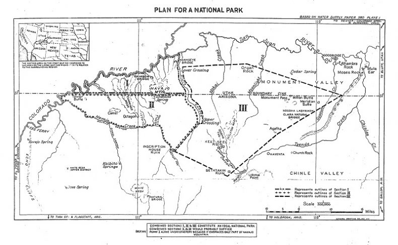
The recent controversies swirling around Bears Ears National Monument are only the latest in a series of struggles resulting from attempts to increase federal government involvement with exceptional places in the Utah/Arizona borderlands region of the Colorado Plateau. Elmo R. Richardson discussed one of the earlier fights in his article, “Federal Park Policy in Utah: The Escalante National Monument Controversy of 1935-1940”, in the Spring, 1965 Utah Historical Quarterly. Proponents of that monument had their sights set on much of Glen Canyon and the region north of the San Juan River. Another early battle, which is less well-known, was a failed attempt in the late 1920s and early 1930s to create “Navajo National Park” on the south side of Glen Canyon and the San Juan River, encompassing the area known as the Rainbow Plateau, and, in some proposals, also the Segi Mesas and Monument Valley.
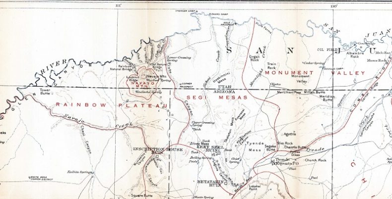
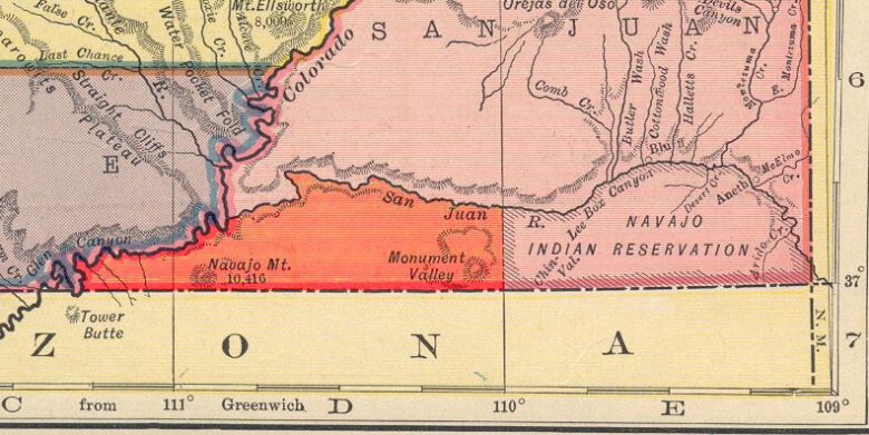
A portion of Herbert E. Gregory’s map of the Navajo Country, including the Rainbow Plateau, Segi Mesas, and Monument Valley
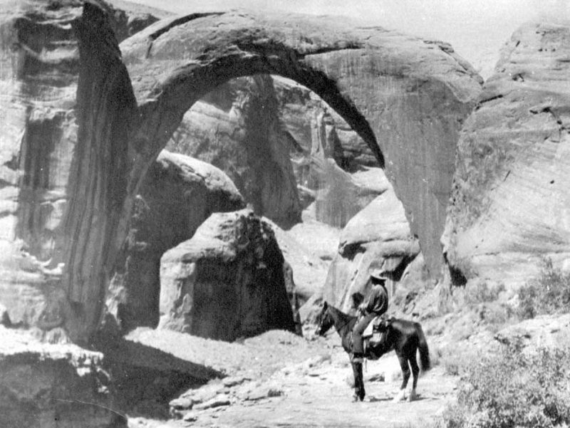
The Rainbow Plateau contains many outstanding landmarks, including Navajo Mountain, Rainbow Natural Bridge, Cummings Mesa, and Forbidding Canyon.
Pioneer geologist Herbert E. Gregory, who named the Rainbow Plateau, called it
the most inaccessible, least known, and roughest portion of the Navajo Reservation…. The deep canyon trenches are practically impassible and the buttresses flanking the cathedral spires are so narrow, smooth, and rounded that passage from one to another and access to the capping mesas have so far not been attained. Whether the ancient cliff dwellers made use of these mesa tops is yet undetermined…. The experience of my party indicates that exploration in this canyoned land may be accompanied by hardships.
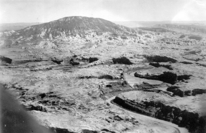
Navajo Mountain and its rugged surroundings are the heart of the Rainbow Plateau. Aerial view looking south across Glen Canyon and the San Juan River.
The first discussion of a government reserve in the region probably occurred around the campfire on one of Charles L. Bernheimer’s expeditions in the latter half of the 1920s. Bernheimer, a self-styled “Tenderfoot and cliff dweller from Manhattan”, came out west to explore the territory year after year and developed a deep appreciation for its rugged and wild beauty. He was guided by Zeke Johnson of Blanding, Utah and my great-grandfather, John Wetherill of Kayenta, Arizona. (For more information on Bernheimer, see “The Gentleman Explorer: Charles Bernheimer and his Canyon Country Expeditions” in the August/September 2018 Zephyr.)
In January 1929 he made a presentation to National Park Service personnel in Washington, D. C. and urged them to consider national park status for the region. He furnished a map showing alternatives for the proposed protected areas.
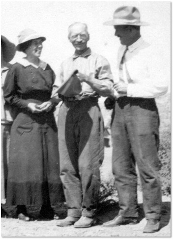
At about the same time, Professor Byron Cummings of the University of Arizona wrote Arizona Senator Carl Hayden, urging his support of the project. Cummings was a pioneer explorer of the territory who, beginning in 1908, conducted field trips there with his students. He was a leader of the 1909 expedition that brought to the world’s attention the existence of Rainbow Natural Bridge and a long-time friend of John Wetherill and his wife, Louisa. “Very little of the land can ever be devoted to agriculture,” Cummings wrote. “The productive area is suitable for grazing only, and if these grazing rights could be preserved to the Indians, and the section withdrawn from private entry, a permanent and healthful blessing could be conferred upon all the lovers of the wonderful out of doors of northern Arizona and southern Utah. Hoping that you will feel that you can conscientiously take a hand in keeping this area as a National playground for the people, we remain, Sincerely yours, Byron Cummings”.
Cummings probably wrote the letter at John Wetherill’s request, but his characterization of the proposed park as a “playground” would not have been consistent with the vision of either Wetherill or Bernheimer. Both men had come to recognize the spiritual and moral benefits of human connection with unspoiled nature—an insight that the traditional Native Americans had known all along. They were trying to preserve one of the remaining pieces of it for the benefit of future generations.
The Wetherills had moved to the country in 1906, and John had spent a great deal of his time guiding clients on horseback excursions since then. He occasionally was rewarded with observing life-changing effects on his clients from their wilderness experiences. One of the most eloquent was Winifred Hawkridge Dixon who went with Wetherill to Rainbow Bridge in 1919. “We had a sense of courage toward life new to us all,” she wrote. “The mere fact of our remoteness helped us shake off layers and layers of other people’s personality, which we had falsely regarded as our own and showed us new selves undreamed of.”
Shortly after Bernheimer and Cummings made their appeals to the federal government, John Wetherill received word that the Bureau of Indian Affairs was considering annexing the so-called Paiute Strip to the Navajo Indian Reservation. The strip, which was the heart of the proposed park, was the portion of San Juan County, Utah west of longitude 110° and south of the San Juan River.
In 1884, President Chester A. Arthur had issued an executive order that designated the area and part of Arizona as “withheld from sale and settlement” and set apart “as a reservation for Indian purposes”. In 1892, President Benjamin Harrison reversed President Arthur’s order for the Utah portion of that reservation. In 1907, the Department of the Interior administratively designated the strip for the use of Paiute Indians. In 1922, Interior once again restored the area to public domain. In the meantime, Navajos living in the region wrote letters to the Bureau of Indian Affairs asking why their traditional homelands were not reserved for their exclusive use.
Wetherill, believing that annexation of the area to the Navajo Reservation would put a stop to creation of the national park, notified Bernheimer. Bernheimer wrote Park Service Director Horace M. Albright, who responded that he was unaware of those plans. Albright contacted Bureau of Indian Affairs Commissioner Charles H. Burke, who confirmed that that was indeed in the works. “…the Indians… are naturally a shepherd folk, engaged in the raising of sheep and cattle, depending solely on their herds for support and have now reached the stage where their present reservation is so overcrowded with livestock that it is very difficult to find land suitable for ranging their stock, and due to this condition many hundred head are lost during the Winters.”
Bernheimer, who was now on his western expedition, reacted strongly. He sent a telegram to Senator Lynn J. Frazier of North Dakota, saying, “FACTS IN LETTER TO ME FROM COMMMISSIONER CHAS H. BURKE DATED MAY FOURTEEN RELATING TO THE JOINING OF THE PIUTE INDIAN RESERVATION TO THE NAVAJO INDIAN RESERVATION ARE BASED ON MISINFORMATION.” Bernheimer also noted that some of the citizens of southeastern Utah agreed with his telegram. Their primary concern was that the change would prevent them from using the strip for grazing their own livestock.
The Indian Service forwarded Bernheimer’s telegram to the initiator of the annexation proposal, Superintendent C. L. Walker of the Western Navajo Indian Agency at Tuba City, Arizona. Walker replied, reiterating his position that the Navajos needed the additional land for livestock grazing, and he expressed his opposition to the new National Park. “While it is believed that the park would not be detrimental to Indians provided that they are not molested, and are allowed to retain their present status within the area, it is not believed just to sacrafice [sic] their possibilities of acquiring this land in order to establish a play ground for white people upon the recommendation of so few.” Walker, whose job was to “civilize” the Indians, only considered the options of grazing and playing. He did not comprehend or acknowledge the profound spiritual connection his wards had to the land and was oblivious to the other option of preserving the pristine character of the land for the benefit of all people.
At about the same time, the Navajo Tribal Council became aware of Bernheimer’s telegram. Four of their delegates sent a petition to Washington in which they listed a number of reasons that the northern expansion to their reservation needed to move forward.
Given the outstanding character of the region, it would seem that the Park Service would have pursued establishment of the new reserve more aggressively. Such was not the case, however. It was not uncommon for proposals to come in that promoted places that did not rise to the National Park standards but seemed designed more for the financial benefit of their supporters. Also, at that late date, the Park Service assumed that they were already aware of all places of outstanding scenery. In August, 1929, Arno B. Cammerer, assistant director of the Park Service, weighed in on the proposition. “Ever since this national park was first proposed by Mr. Bernheimer, I haven’t for the life of me been able to see it. There may be possibility for enlarging several of the existing national monuments by including some of the other scenic and prehistoric areas, but even that may have its problems. I’m agin it,” he noted. However, he did recommend a visit to the region by Park Service representatives, and he designated a liaison with the Bureau of Indian Affairs to engage in further discussions.
During the next few months, the position of the Bureau of Indian Affairs softened, and they suggested that the park designation might be viable, even if the reservation was expanded. Superintendents of the Northern and Western Navajo Agencies conceded that park designation of the Rainbow Plateau area north of the Arizona line would not be a major detriment to the Indians, but they differed in their opinions on the size of the park. Subsequent discussions between National Park Service and Bureau of Indian Affairs personnel concluded that the proposed park might be viable if it was jointly managed by both agencies.
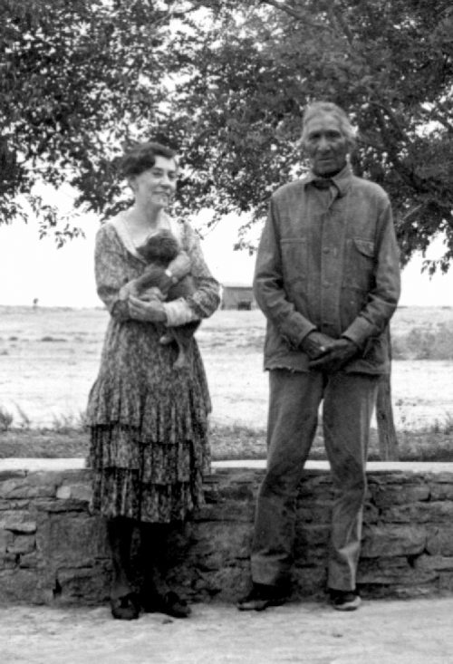
On July 7 and 8, 1930, the Navajo Tribal Council met and included in their agenda a discussion of the annexation of the Paiute Strip. It was noted that the Wetherills, among others, objected to it. This created some friction between the Wetherills and their Navajo friends. Former Tribal Council Chairman Chee Dodge said, “The Wetherills always claimed to be our friends. I would like to know why they have turned against us—there must be something we don’t know about—they probably have some good reason for it.”
Louisa Wetherill was in the audience and tried to explain the family’s position. “We are for the Indians first, last, and all the time,” she said.
Late in December of 1930, John and Louisa Wetherill received two visitors from southern California at their home in Kayenta. They were Frederic A. Stearns and Pat Flattum who had brought in tow a unique metal boat that they had designed and built. They wanted to test it by motoring up the Colorado River into Glen Canyon and back, even though ice was flowing in the river and the days were bitterly cold. John Wetherill convinced them that they should not attempt such a trip into unknown territory under such adverse conditions by themselves. He offered to serve as guide, and, since there would be space for only two people, Stearns agreed to stay behind. When the men got on the water, it became evident that the new boat was of no use. They commandeered an abandoned wooden boat and proceeded on their voyage, changing the purpose of the trip to an information and photograph gathering endeavor to provide the Park Service with concrete evidence of the awesomeness of the canyon. (For more information on this trip, see “The Strenuous Life” in the August/September 2017 edition of the Zephyr).
In March, the Park Service sent Grand Canyon National Park Superintendent M. R. Tillotson and Yellowstone National Park Superintendent Roger W. Toll to Kayenta, Monument Valley, and Rainbow Bridge to provide a first-hand appraisal of the area. They were duly impressed. Toll documented their findings in a letter to the Director of the Park Service: “It is recommended that the areas referred to be established as the Navajo National Park, under an agreement with the Indian Service” he concluded. “The area is of such outstanding scenic quality that it would be an important addition to the national park system. The scenery is varied, full of interest and is of impressive magnitude. Monument Valley, Tsagi Canyon, Navajo Canyon, Rainbow Bridge and its vicinity are among the spectacular features of the area.”
Park Service authorities in Washington were somewhat taken aback by such a favorable review. Arthur E. Demaray, an administrator, reviewed the report. “This is an unusual case, our park expert Mr. Toll and Supt. Tillotson both agree that this area is of national park standard, but others who have not seen the area do not agree as to their recommendation. We ought to give further study to this project.”
In August, Conrad L. Wirth, who was assistant park service director in the branch of planning, recommended that “Mr. Toll’s report be accepted and the matter be taken up with the Commissioner of Indian Affairs with a view of working out a draft of bill which would protect the rights of the Indians while providing for the establishment of this proposed national park.” Park Service Director Horace M. Albright approved the recommendation in November. However, the Commissioner of Indian Affairs, Charles J. Rhoads, was not enthusiastic about the project.
To help move the proposal along, John Wetherill contacted Neil M. Judd, the curator of archaeology at the United States National Museum in Washington, D. C. The two had first met in 1908 while Judd was a student at the University of Utah and a participant in the summer archaeological field trip of his uncle, Professor Byron Cummings. Judd had returned in 1909 and was a member of the expedition that brought to the world’s attention Rainbow Natural Bridge. Wetherill asked Judd to try to convince Park Service Director Albright to come and see the wonders of the region for himself. Albright consented.
On June 30, 1932, Albright arrived in Kayenta with some of his staff. Wetherill guided the party to Rainbow Bridge and the top of Navajo Mountain.
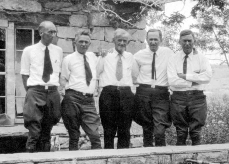
June, 1932 Park Service meeting at Kayenta. Left to Right: Mesa Verde National Park Superintendent Marshall Finnan, Grand Canyon National Park Superintendent M. R. Tillotson, Navajo National Monument Custodian John Wetherill, National Park Service Director Horace M. Albright, and Southwest National Monuments Superintendent Frank “Boss” Pinkley.
Albright expressed his enthusiasm for the country in a letter to Neil Judd that he wrote from Rainbow Lodge on the side of Navajo Mountain. “I have seen Rainbow Bridge. I have ridden to the top of Navaho Mountain, and I have seen all the other glories of this great country just south of the San Juan. What a country it is!”
Wetherill added his own note to the letter. “I think that Mr. Albright is propperly [sic] enthused over the country that you helped to discover. We thank you for what you did to help get him here. With best wishes from your old side kick.”
In the meantime, a committee of nine leading residents of southeastern Utah met with some representatives of the Bureau of Indian Affairs and worked out conditions of agreement for the annexation of the Paiute Strip to the Navajo Reservation. Their memorandum of agreement, dated July 15, 1932, included this statement: “It is agreed that the scenic tracts are to be developed by the National Park Service, with the cooperation of the Indian Service.” Commissioner Rhoads approved the document.
Horace Albright proceeded to California on his extended western trip and ran into some of the Wetherills’ old friends at the Bohemian Grove. He wrote John Wetherill from Berkeley. “We all agreed that Mrs. Wetherill and you were among the best folks in the world and that there is no more hospitable and interesting national park place than yours at Kayenta.” Thenceforth, Albright was one of the strongest proponents of Navajo National Park. He knew, however, that it would still be a battle to get it implemented.
On October 14, Albright wrote Indian Commissioner Rhoads requesting a meeting to discuss the park proposal. Rhoads replied by forwarding a copy of House Resolution 11735, which included adding the Paiute Strip to the Navajo Reservation, but had no language relating to the national park. “In view of the fact that we now have the assent of the local citizens and of the Navajo tribe to the bill as now drawn, we would prefer not to disturb the bill in any way at this time, but await its enactment and thereafter take up with you the matter of creating the proposed national park…”, Rhoads replied. Albright agreed to that approach.
On November 14, National Park Service Chief Forester Ansel Franklin Hall arrived at Kayenta with the Grand Canyon artist, Gunnar Widforss. Hall had recently demonstrated his organizational abilities by sending Boy Scouts on naturalist expeditions to national parks to conduct scientific studies and participate in work projects.
“There’s an area of some six or seven hundred square miles lying between here and the San Juan and the Colorado that certainly needs looking into,” Wetherill told Hall. “Say, Mr. Hall, why don’t you organize an expedition like you’ve been sending out the past five years for scientific exploration? Send a group of scientists into this country and turn out a report that will tell the National Park Service and the world about what’s up there in that maze of canyons.” That conversation was the genesis of the multi-year Rainbow Bridge—Monument Valley Expedition that sent scientists and students into the proposed park area and published reports on the wonders of the region.
On March 1, 1933, House Resolution 11735 was enacted, adding the Paiute Strip to the Navajo Reservation. The Park Service had initiated dialog with the Navajo Tribal Council regarding the new national park within the reservation and sent to the new Commissioner of Indian Affairs, John Collier, a draft bill that included a legal description of the park boundaries. Horace Albright resigned as Park Service Director in July.
The Navajo Tribal Council did not rule on the proposal until July of 1934. They issued a resolution that stated: “Whereas the Navajos have a greater love for their country and its beauties than any other people can possibly have, and wish to guard against any changes that may make any part of their country less beautiful…. Therefore, it is hereby resolved that all areas of scenic beauty and scientific interest which require preservation be hereby reserved as Navajo Parks, Monuments, or Ruins, to be managed by the Navajos themselves with the cooperation of the Indian Service and all other helpful agencies; and be it further resolved that the Council petition the Secretary of the Interior and the Commissioner of Indian Affairs to take immediate steps to have the National Park Service relinquish any rights that they may have required to any of our areas.”
This resolution was the death knell for Navajo National Park. Horace Albright was devastated that the plans fell through. “I wasn’t used to defeat,” he wrote. “I always won. I always got what I wanted. It has hung on me. in has hung on me all my life.” The failure was undoubtedly extremely disappointing to John Wetherill, as well.
We can only speculate what might have been different if the park proposal had gone through. There most definitely would have been greater impact to the pristine character of the region from Park Service infrastructure, publicity, and visitation. On the other hand, there most likely would have been some mitigation from impacts of overgrazing that have occurred over large portions of the area. Perhaps most significantly, twenty-two years after the Navajo Tribal Council issued their resolution, the destiny of the region was dramatically altered when Congress authorized construction of Glen Canyon Dam to impound the waters of Lake Powell, resulting in inundation of the northern portion of the proposed parkland. Former Secretary of the Interior Stewart Udall believed that, had the park been created, “there would be no Glen Canyon Dam.”
It was not until 1964 that the Wilderness Act was passed to protect areas “where the earth and its community of life are untrammeled by man, where man himself is a visitor who does not remain.” Perhaps the concept of Navajo National Park was simply several decades ahead of its time.
More than thirty years ago, Harvey Leake began researching the history of his pioneering ancestors, the Wetherills of the Four Corners region. His investigations have taken him to libraries, archives, and the homes of family elders whose recollections, photographs, and memorabilia have brought the story to life. His field research has led him to remote trading post sites in the Navajo country and some of the routes used by his great-grandfather, John Wetherill, to access the intricate canyon country of the Colorado Plateau. Harvey was born and raised in Prescott, Arizona. He is a semi-retired electrical engineer.









Comprehensive history of efforts by John Wetherill and others to create a National Park in the area. Excellent detailed account of the many heroic attempts. Fascinating article.
Another great article Harvey; Questions remain as to how wise it was for Anglos to lump Paiute and Navajo together. These two indigenous groups shared common ground, but were each their own tribe. It was the arrogance of Interior Secretary Albert Fall (of Teapot Dome scandalous fame) who instructed the BIA to falsely report that the San Juan Paiute were not using their “new” reservation, which led the Strip to being returned to the public domain in 1922. So the Paiute were placed under Navajo control in 1933, and the San Juan Paiute lost all representation. The Paiute never received a federal agency of their own.
Also, your summary statement suggests that had a National Park been established, then there would not have been a Glen Canyon Dam or Powell reservoir. I’m not so sure. This was a major political football and “Indian” water rights were completely ignored in the original CRC signed in 1922; as were their rights to land. I for one, am glad no NP ever happened, as once again, you only need to look at all the Parks in region and nearby towns; the sacred Navajo Mtn would be no more! Picture a McDonald’s at Rainbow Lodge; traffic jams at Shonto? The Oljeto Hilton? Really?