NOTE: I wrote this article in December 2008. We were trying to warn Moab and Grand County residents of future SITLA developments, even then. Particularly note references to the Lion’s Back Resort, as far back as 2006. At the time, Moab conservationists like Bill Love did not believe opposing Lions Back was worth the effort. Ten years later, it appears finally that some interest has been aroused…JS
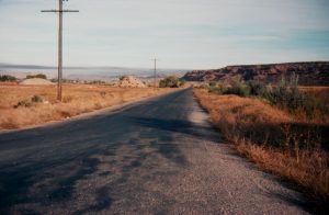
Last summer, road work at the far south end of Spanish Valley, in San Juan County puzzled me for months. Two major intersections were under construction, about a mile apart, complete with turning lanes and fresh striping. But the new roads went nowhere; the pavement traveled exactly 50 yards east to the highway right-of-way fence and stopped. Other than a vague double dozer track on the other side of one of them, leading into the pinyon-juniper, I could see no plan to proceed further. Then it occurred to me—these were Utah State Institutional Trust Lands and I wondered what SITLA was up to now.
I’d heard some speculation that the two new road intersections might have something to do with the never ending rumor that Wal-Mart planned to build on San Juan County SITLA lands. They’d make excellent Wal-Mart entrances for north and south-bound traffic.
But Bryan Torgeson of SITLA dismissed the rumor. “I’ve gotten those same Walmart speculation questions. However, I want to once again clarify that there is still no Walmart coming to San Juan County that I’m aware of and those turn lanes were not put in to accommodate any proposed big box development.”
He explained that WW Clyde leases a gravel pit in Spanish Valley and was hoping for a more direct route to their pit. San Juan County and the BLM also got involved in the project. A more direct route to Ken’s Lake from US 191 would enhance fire response times.
Then, according to Torgeson, “San Juan County looked at the road networks further south and determined that in addition to the new Ken’s Lake road that another route could help with their road issues. They desired another route in the southern part of Spanish Valley. This proposed southern route was identified to relieve the traffic onto Spanish Valley Drive coming from Pack Creek and the Loop Road.”
Finally, Torgeson noted, “The above were the main reasons and events that led to the decisions of the roads and turn lanes. However, we will likely have future development needs in the area. They will likely take place in the medium to far term. Those future development needs have not yet been identified or proposed, but the roads could facilitate any future development needs of SITLA’s as well.”
Indeed, along much of US 191, from Moab to Blanding, many SITLA sections that are adjacent to the highway, with easy access, are being developed for their residential potential. From the Lion’s Back project and Cloudrock on Johnson’s-Up-On-Top, to the top of Blue Hill, to the Wilson Arch Resort, to Flat Iron Mesa, to the ridge just north of Hatch Wash, to the Needles intersection and the area near the old Home of Truth, even to State Route 95, south of Blanding, just a half mile from its intersection with US 191—ALL of these locations are under various degrees of development. On almost all of them, home construction to some extent is underway.
Torgeson confirmed that, “Those developments that you referenced were once Trust Land. As was a majority of the private land throughout the state.”
Whether the SITLA lands in Spanish Valley are developed to their full potential depends on many factors but, according to Torgeson, “What I can say is that all of the SITLA properties located in the Spanish Valley Area are designated for future development.” He noted that the current economic downturn could mean that full development is in the distant future.
Is there any opposition to this longterm plan to exurbanize the rural lands of Southeast Utah into a web of ranchettes?
The Utah Recreational Land Exchange Act of 2007, sponsored by Rep. Jim Matheson (D-UT) and Sen. Bob Bennett (R-UT) stalled in both houses of Congress this year and awaits action in 2009. The legislation “protects valuable conservation lands along the Colorado River corridor near Moab by exchanging them with lands that are more suitable for development and may be used to benefit Utah’s school children.”
The Southern Utah Wilderness Alliance notes that, “Throughout Utah, state parcels lie within or adjacent to areas proposed for wilderness in America’s Red Rock Wilderness Act, threatening the long-term protection of those areas. This bill places those lands in federal ownership in exchange for more developable land elsewhere for the state, and additionally withdraws approximately 20,000 acres of wilderness quality public land from all forms of mineral entry.”
for more: ‘The Land Exchange Bill that went OOOPs.’
http://www.
But while the bill addresses and would protect specific lands adjacent to the Colorado River, the patchwork development of SITLA lands elsewhere goes essentially unchallenged by anyone. One thing is certain, SITLA’s goal is to develop those lands to their fullest economic potential and as long as that development is not related to mineral development or cattle grazing, environmentalists have little interest in objecting.
In 2003, noted Moab conservationist Bill Love posted an email about overgrazing on those very state sections in upper Spanish Valley that are being discussed here. He wrote: “Range Net is running a contest for the most overgrazed allotment in the western United States. The SITLA land around Ken’s Lake has been nominated.”
But what’s worse? I asked Bill: “I’m trying to get a feel for just where environmentalists stand on this grazing issue….If SITLA announced that it wanted to take that overgrazed allotment and build 500 affordable housing units on it—would that be an agreeable alternative for you?”
Bill replied, “Your question cannot be answered because you are assuming there are only two choices for public lands and those are a cow or a house. Your question ignores the many alternatives that can include recreation, wildlife, housing, gravel mining, and grazing in the Ken’s Lake area. I cannot pick a house or a cow as the solution”
So…me being me, I pressed: “It’s purely hypothetical Bill…if you had only those two choices which is the lesser of two evils. Choosing the lesser of two evils is hardly a strange concept. It is the foundation of American politics. Can’t just ONCE…a Utah enviro give a straight answer? I can…if those were my only choices I’d leave it overgrazed.”
I didn’t hear from him again…the unanswered question lingered.
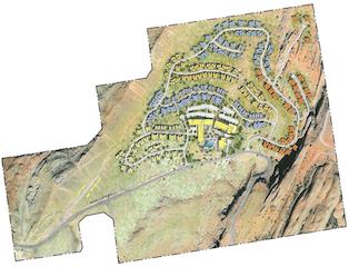
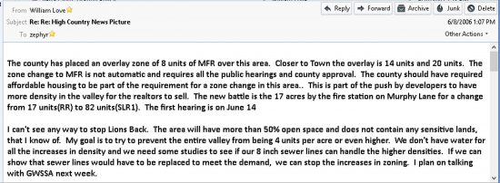
Three years later, in 2006, SITLA moved forward with plans to develop a state section just east of the city limits, the Lions Back Resort; I asked Bill Love what could be done to stop it. Love wrote, “I can’t see any way to stop Lions Back. The area will have more than 50% open space and does not contain any sensitive lands, that I know of. My goal is to try to prevent the entire valley from being 4 units per acre or even higher.”
If rural Utahns have any hope of stopping further development of remote SITLA sections, they need to act now, on lands not even under current consideration. Get out your maps. Look at the locations of ALL SITLA lands adjacent to paved roads in scenic area. That is your SITLA blueprint for the future.
The article was printed in the December 2008/January 2009 issue of The Zephyr.














0 Responses
Stay in touch with the conversation, subscribe to the RSS feed for comments on this post.